NTU study finds major earthquakes cause land sinking in Southeast Asia
New research shows that massive earthquakes trigger slow-motion land subsidence that can persist for years, impacting regional relative sea-level rise.
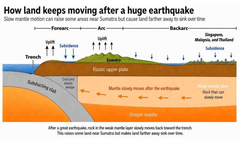
Large-scale seismic events in Southeast Asia trigger a long-term, slow-motion subsidence of land that can persist for years, according to research published by Nanyang Technological University (Ntu) on July 10.
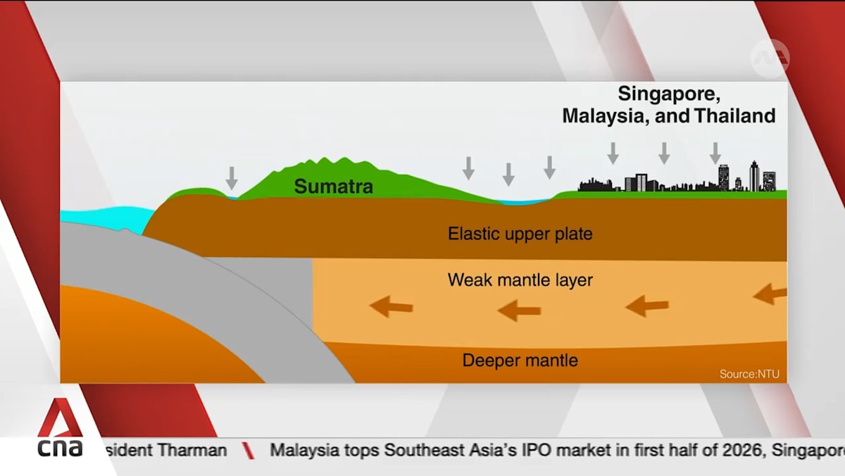
The study, which appears in the journal Communications Earth & Environment, identifies a critical, geologically active mechanism: a layer of hot, solid rock within the upper mantle beneath the Sumatran backarc, the region located behind Sumatra’s chain of volcanoes. Researchers found that this layer is weak enough to deform and flow slowly after being subjected to the stress of a major tremor. As this underground material shifts, the Earth's crust above it gradually sinks.
Related YouTube video


Long-Distance Impact
The team analysed up to two decades of data from ground-based Global Navigation Satellite System (GNSS) stations located across Singapore, Malaysia, and Thailand. They specifically examined the long-term aftermath of the 2004 Sumatra-Andaman earthquake and the 2012 Wharton Basin earthquakes. The resulting data demonstrated that the ground continued to shift even in locations situated more than 600 kilometres from the initial earthquake sites.
Grace Ng, a research fellow at the Earth Observatory of Singapore (EOS) and lead author of the study, explained that the impact of massive earthquakes extends far beyond the immediate few minutes of shaking.
"When massive earthquakes strike, they do not just shake the ground for a few minutes. They set off a slow adjustment deep within the Earth that can continue for years."
Grace Ng, lead author, via NTU
Ng noted that conducting such a study prior to 2004 would have been difficult, as many of the continuous satellite positioning stations needed to measure long-term deformation were installed only after the 2004 disaster. A previous study looking at the causes of vertical land motion found that three of the earth’s most powerful earthquakes in Sumatra caused Singapore to sink at rates of up to 2.2 millimetres annually between December 2004 and April 2012. Except for this period of tectonic movement, the main island was generally stable, with the sinking being close to zero.
Implications for Coastal Planning
While global sea-level rise is driven by climate-related factors such as ocean warming and the melting of ice sheets, coastal planners must also contend with the movement of the land itself. Known as relative sea level, this measurement tracks the height of the sea compared to the specific local landmass. When the ground subsides due to post-earthquake geological adjustments, local relative sea levels rise faster than they would from climate drivers alone.
Emma Hill, the AXA-Nanyang Professor in Earth and Environmental Science and the study's senior author, stated that failing to account for this vertical land motion leads to an underestimation of flood risks.
"Most current sea-level projections focus primarily on climate factors like ice-sheet melting and ocean warming, but we must also look at how the Earth moves beneath our feet. Our new study shows that post-earthquake land sinking is an important factor in regional relative sea-level change. Incorporating these deep geological movements into our models will help us improve coastal planning for low-lying cities."
Emma Hill, senior author, via NTU
Current Status and Next Steps
The team suggests this geological phenomenon is likely occurring in other subduction zones globally where tectonic plates collide.
Lujia Feng, a co-author and assistant professor, emphasised the necessity of the long-term observational networks that made the discovery possible.
"This study would not have been possible without more than a decade of continuous observations from ground-based GPS networks across the region. Such long-term geodetic records are vital for revealing how the solid Earth responds to great earthquakes, and how these processes evolve over time."
Lujia Feng, co-author, via NTU
Archypedia is dedicated to independent, evidence-backed reporting. This briefing was synthesized from primary source reporting, corroborated across independent newsrooms, and verified against our Editorial Standards.
Transparency record
Evidence behind this report
This report synthesizes 8 distinct sources. Open the source ledger below to compare the underlying coverage.
- newsbreak.com
- ntu.edu.sg
- miragenews.com
- channelnewsasia.com
- straitstimes.com
- thestar.com.my
- brightsurf.com
- lifetechnology.com
Prepared under the Archypedia Editorial Policy by the Niko Vale editorial desk profile. AI-assisted tools may support drafting and verification; public accountability remains with Archypedia. Report an error.