Hurricane Lowell lashing Hawaii, knocking out power and bringing flood risks
Hurricane Lowell lashed Hawaii's western islands with torrential rain and high winds, knocking out power to tens of thousands of customers and triggering flash flood risks.

HONOLULU — Hurricane Lowell lashed Hawaii's western islands on Tuesday, Sept. 8, 2026, unleashing torrential downpours topping 17 inches and wind gusts reaching up to 80 mph. The storm knocked out power to tens of thousands of customers, ripped up beachside roadways, and triggered severe flash flood and mudslide risks. Emergency officials urged residents to stay off roads as crews confronted blocked routes, downed trees, and widespread structural damage.
While the storm center passed west of the islands according to official tracking data, the punishing combination of high surf, sustained tropical storm-force winds, and torrential rainfall left communities isolated. The CBS News reporting on Hurricane Lowell detailed how infrastructure strains rippled across multiple islands, mirroring broader coverage from Yahoo News and The Mercury News detailing the swift emergency response.
Related YouTube video

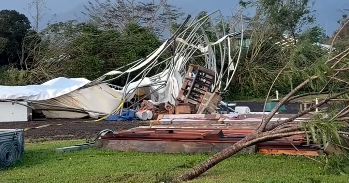
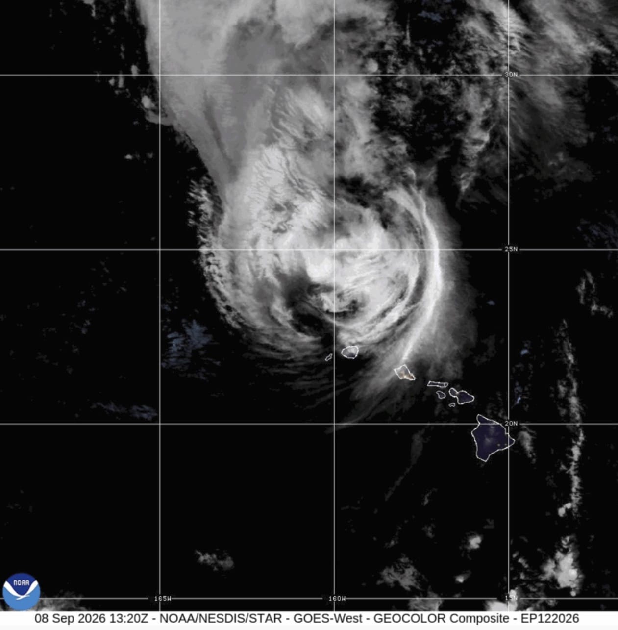
Trajectory, Wind Severity, and Competing Tracking Data
Official accounts from the Miami-based National Hurricane Center, as reported via Usa Inquirer and Associated Press dispatches, stated that the center of Lowell passed west of the islands during the overnight hours and moved away through Tuesday. Sustained winds measured just above 50 mph at Lihue Airport on Kauai, while the hurricane center noted wind gusts reaching up to 80 mph. Hurricane warnings for Kauai and Niihau, alongside tropical storm warnings for Oahu, were lifted by Tuesday morning.
Conversely, The New York Post reported that powerful Category 2 Hurricane Lowell made a rare direct hit on Hawaii's western islands late Monday night Hawaii time. Citing the National Hurricane Center's threshold that a direct hit occurs when a storm passes within twice the radius of maximum winds — in this case, 70 miles, reporting from the field highlighted maximum sustained winds of 105 mph as the center began pulling away north-northwest of Niihau. FOX Weather correspondents on the ground recorded wind gusts over 80 mph on Kauai's eastern side and between 65 and 85 mph on Niihau.
On-the-Ground Disruption and Utility Failures
The physical toll on Kauai and surrounding islands disrupted daily life and compromised essential supplies. The Kauai Island Utility Cooperative confirmed that nearly all of its roughly 35,000 members lost power early Tuesday. Utility tracker PowerOutage.us registered approximately 42,000 total statewide outages by early Tuesday afternoon, while alternate tracking cited upwards of 60,000 customers in the dark across Kauai and Oahu combined.
| Metric / Indicator | Reported Figure | Source / Context |
|---|---|---|
| Peak Rainfall (Hanalei) | 17.76 inches | Kauai community monitoring via CBS News |
| Statewide Outages | ~42,000 customers (up to 60,000+ combined) | PowerOutage.us tracking data |
| Sheltered Residents (Kauai) | ~300 individuals | Kauai County Mayor Derek Kawakami |
| Sustained Winds (Lihue Airport) | Just above 50 mph | National Hurricane Center |
Roadways suffered severe impairment. Boulders, sand, lava rocks, and downed trees cut off entire neighborhoods, particularly along Kauai's southern coast where waves tore apart coastal roads. In Kōloa, storm surges and heavy rain submerged local streets, while on Oahu, road crews cleared debris from a major route along the western edge after floodwaters topped a coastal highway north of Honolulu. Governor Josh Green ordered the closure of schools and government offices across the three affected islands for Tuesday.
Human Toll and Personal Accounts
Residents and visitors alike faced immediate logistical and medical hurdles. Tourist Dave Reed, visiting for a wedding, recounted riding out the storm with family. It was actually pretty scary,
Reed told CBS News. I always said I want to ride out a hurricane. I never want to do it again.
For locals with medical dependencies, the blackout created acute danger. Andrew Davis Henry, a diabetic resident of Kauai without cell service or power, searched urgently for ice to preserve his insulin. I need that to live, so if I don't have that, it's going to be a bad day for me,
Henry told CBS News.
Property destruction was vividly apparent on Kauai, where CBS News cameras documented a waterfront home completely lifted off its foundation and deposited across the street. Meanwhile, Rochelle Ballard, a former professional surfer running a surf school on Kauai's southern coast, noted that cleanup would take weeks following severe wave action that destroyed a friend's house.
Frequently Asked Questions
Where was Hurricane Lowell centered, and were warnings lifted?
The National Hurricane Center reported that the storm's center passed west of the islands early Tuesday and moved away, allowing hurricane warnings for Kauai and Niihau and tropical storm warnings for Oahu to be lifted by Tuesday morning.
What were the highest rainfall totals and power outage figures recorded?
Hanalei recorded the highest rainfall total at 17.76 inches, with projections reaching up to 24 inches in some areas. Statewide power outages affected roughly 42,000 customers according to utility tracker PowerOutage.us, with near-total blackouts reported among Kauai Island Utility Cooperative members.
Looking ahead, meteorologists emphasized that environmental hazards remain active. Eric Blake of the National Hurricane Center warned that flooding and mudslides will continue to pose a risk through the day, particularly across urban and low-lying regions as well as the Big Island, which suffered prior slope damage during Hurricane Lala the previous month. As Lowell weakens and moves further north at 15 mph with maximum sustained winds of 75 mph, emergency management officials continue to assess structural stability and clear blocked arteries across the western islands.
Archypedia is dedicated to independent, evidence-backed reporting. This briefing was synthesized from primary source reporting, corroborated across independent newsrooms, and verified against our Editorial Standards.
Transparency record
Evidence behind this report
This report synthesizes 6 distinct sources. Open the source ledger below to compare the underlying coverage.
Prepared under the Archypedia Editorial Policy by the Niko Vale editorial desk profile. AI-assisted tools may support drafting and verification; public accountability remains with Archypedia. Report an error.


