NASA PACE satellite tracks wildfire smoke and vegetation health
Originally designed for ocean observation, NASA's PACE satellite is providing new insights into terrestrial fire tracking and atmospheric smoke plumes. The mission uses hyperspectral instruments to assess vegetation stress and map burn scars.
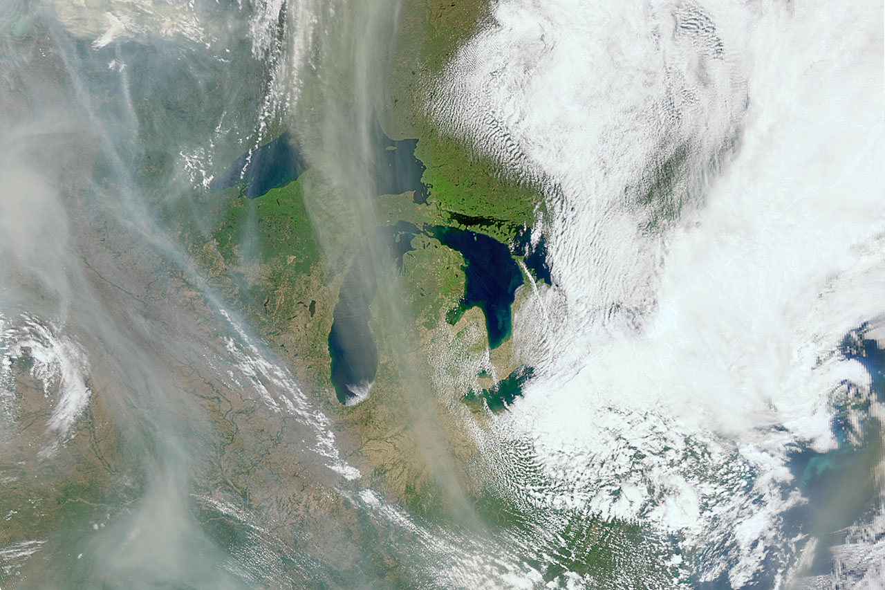
As the North American fire season progresses, NASA’s Plankton, Aerosol, Cloud, and ocean Ecosystem (PACE) satellite, which launched in February 2024, is providing new insights into the life cycle of wildfires. While the mission was primarily developed to observe the Earth's oceans and atmosphere, its onboard instruments have demonstrated a significant, unexpected capability: the ability to monitor terrestrial vegetation and the environmental precursors that lead to fire outbreaks.
The mission utilizes three specialized instruments to gather hyperspectral data, viewing the planet in hundreds of different wavelengths of visible, near-infrared, and ultraviolet light. According to Skye Caplan, terrestrial lead for the PACE mission at NASA’s Goddard Space Flight Center, the satellite’s capacity for observing land surfaces provides a powerful new data set for researchers.
"The PACE satellite observes land too, and does it really well. There is so much to explore with a new hyperspectral data set."
Skye Caplan, terrestrial lead for the PACE mission at NASA Goddard, via NASA
The Ocean Color Instrument is central to this effort, allowing scientists to assess the health of plants by measuring their relative pigment balance, dryness, and levels of stress. By identifying areas of vegetation prone to high fire risk, land managers can theoretically distribute resources more effectively to mitigate potential disasters. Once fires do occur, the instrument’s daily global coverage allows scientists to map the resulting burn scars and monitor them over time, which is particularly important as charred land often faces elevated risks of landslides and flooding.
Beyond identifying high-risk zones, PACE plays a critical role in tracking the movement of smoke plumes. By utilizing ultraviolet wavelengths, researchers can determine the altitude of smoke particles in the atmosphere, a factor that influences how far these particles travel and the systems they impact. This data complements existing observations from satellite tools like the Visible Infrared Imaging Radiometer Suite and the Moderate Resolution Imaging Spectroradiometer.
To differentiate smoke from other atmospheric particulates — such as dust or general pollutants — the mission employs the Hyper-Angle Rainbow Polarimeter 2 and the Spectro-polarimeter for Planetary Exploration one. These tools analyze the chemical properties, shape, size, and color of light reflected off particles. Smoke particulates are typically light absorbing, appearing gray, black, or brown in color, and are small in size compared to other aerosols PACE views, such as pollutants and dust.
According to Kirk Knobelspiesse, a remote sensing scientist at NASA Goddard, this granular data is essential for evolving Earth-modeling systems.
"The challenge that we have is to take those clues and use them in a meaningful way, so our models of Earth properly represent what’s happening."
Kirk Knobelspiesse, remote sensing scientist for the PACE mission at NASA Goddard, via NASA
Knobelspiesse noted that by refining these models, scientists will be better equipped to simulate future scenarios of emissions and understand how smoke created in one location can impact other parts of the Earth system. As the PACE mission continues its orbits, each taking approximately 98.3 minutes at an altitude of 676 km, it contributes to a growing body of data intended to assist public and private organizations in ecological forecasting, disaster management, and the protection of air quality.